
Leeper Aerial focuses on technical UAS-derived photogrammetry projects providing premier quality client deliverables with high relative accuracy.
PHOTOGRAMMETRY
Photogrammetry is a range-imaging technique used to derive digitally scaled models of the three-dimensional structure and form of landscapes, buildings, and other settings, from two-dimensional images acquired by UAVs or handheld cameras.

Sparse point cloud (tie points)

Dense point cloud

Dense point cloud, altitude (R,G,B)
LANDSCAPE DEVELOPMENT
Photogrammetry outputs with high relative accuracy include orthomosaics and digital elevation models, from which elevation contours are derived.

Digital surface model of 6-acre site

Orthomosaic

Digital terrain model

Colored (elevation) digital terrain model with hillshade, contours and vegetation attributes

Orthomosaic with contours and native vegetation species census and vegetation attributes
SITE DOCUMENTATION & ANALYSIS
3D models with high relative accuracy and high resolution enable interpretation of ortho-imagery and derivation and analyses of linear (X, Y, and Z), areal, and volumetric site attributes, i.e., vegetation height, diameter, and area of groundcover.

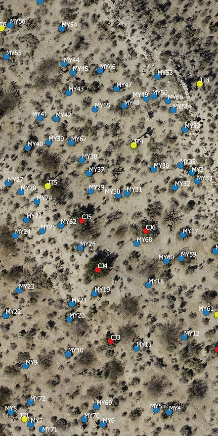
(Above) Mid-workflow image of a 2.5-acre site 3D model showing locations of native desert vegetation species. Pairing and sharing high-resolution 3D models and ortho-imagery online for data and imagery interpretation and analysis with team members helps to ensure efficient workflows and reliable high-quality client deliverables.
Mid-workflow high-resolution orthomosaic depicting native vegetation species census data highlighting Joshua Tree (Yucca brevifolia) [yellow], Mojave Yucca (Yucca schidigera) [blue], and California Juniper (Juniper californica) [red] locations.
REAL ESTATE SERVICES
If you're in the real estate business and want a unique way to show off your listings, consider Leeper Aerial! Using the same technology required for aerial land surveying and mapping, we can provide high-definition videos and 3D scans to give buyers a better idea of properties. To learn more about our real estate-specific services, visit our Real Estate Services page.
3D models (textured mesh or point cloud) with high relative accuracy are usable in architectural drafting software and provide advanced visualizations to help ensure clients are appropriately informed of final structural design plans and aesthetics.
VIDEO
4k video creates a permanent high-resolution digital record in amazing detail that is useful for real estate marketing, site documentation and improving understanding of finer details of a small (< 40-acres) or large (>40-acres) site. 4k video is ideal for initial reconnaissance of large sections of land in the beginning stages of site development brainstorming and planning, and for insurance purposes.